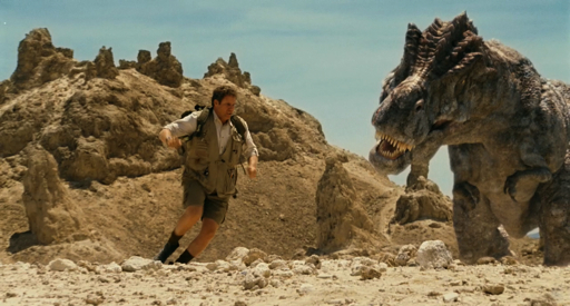
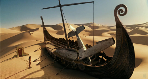
For this week’s Cinema Science we take a look at the Land of the Lost (opening 06.05.09), a remake of the Sid and Marty Kroft Saturday morning TV series of the same name. In Land of the Lost, explorers [Rick] Marshall, Will, and Holly survive the “greatest earthquake ever known” only to find themselves transported to an strange world filled with vengeful dinosaurs, alien technology, and the slow-witted but somehow menacing Sleestak.
Unlike its mid-70’s predecessor which was taped entirely on a soundstage with crude by contemporary standards chromakey effects, the big-screen version of the Land of the Lost has the luxury of state-of-the-art CGI visual effects and location shooting.
For Land of the Lost‘s other-worldly look, producers looked to the nearby Mojave Desert for suitable locations. For years, California’s Mojave Desert has been the go-to location when moviemakers wanted to depict the Western frontier, barren wastelands, or alien worlds. Situated in the Basin and Range southeast of the Sierra Nevada, extension (stretching) of the earth’s crust creates a distinctive pattern of valleys (basins) bounded by mountains (ranges). As the land literally pulls apart from east to west, huge blocks of stone fracture and dip downward, creating the characteristic north/south trending ranges.
This California geological province, called the Mojave Block, is one of the driest and hottest places in the world. It is home to the lowest point in the U.S: Death Valley, a deep rift between the Panamint Range to the west and the Amargosa Range to the east. Each of these ranges, as well as the Inyo Mountains and the Sierra Nevada to the west, cast their 10,000+ foot “rain shadows” across the entire region. Storms from the Pacific cannot make the climb up these mountains, instead shedding their moisture far to the west. Only an occasional seasonal monsoon sneaks in from the south. Wind scours the landscape, picking up sand and blasting it against every surface, pocking it and whittling it down relentlessly. The Mojave can appear to be a hellish alien world, but it also a hauntingly beautiful one.
Trona Pinnacles
Fans of science fiction television and movies have undoubtedly seen the Trona Pinnacles used as the backdrop for countless alien worlds, and Land of the Lost is no exception. After arriving in the Land, Will Farrell’s Rick Marshall finds himself on the wrong side of Tyrannosaurus Rex, nicknamed “Grumpy,” and humorously tries to evade him amidst a forest of jagged stone towers. What are those features anyway, and where did they come from?
 The Trona Pinnacles are rock formations called tufa, a calcium carbonate deposit formed in the waters of deep alkaline lakes. If these lakes are sited over springs, groundwater can percolate into the lake. In the case where groundwater picks up calcium from rocks under the lakebed, the dissolved calcium will react with the soda carbonates in the lake water to produce a calcium carbonate precipitate. When the lakes evaporate, tall stacks of the carbonate are left high and dry.
The formations are quite fragile, and so sites like the Trona Pinnacles and Mono Lake, where tufas are still being formed, must be protected. For example all visitors to the Trona Pinnacles as well as the Land of the Lost production are required by BLM rules to “leave no footprints.”
 The 500-odd tufa pinnacles that make up the Trona Pinnacles formed in what is now called Dry Lake Searles, back when it was one of a chain of lakes that filled with Sierra Nevada glacial runoff at the end of each ice age. As the massive runoff flowed down off the Sierras, an interconnected drainage system that filled lakes from Mono Lake in the north to Death Valley in the south.
The pinnacles are classified into three groups, each group corresponding to different glacial periods from 100,000 years ago for the earliest, to 10,000 years ago for the most recent. The tallest of the towers reach as high as 140 feet, giving an impression of how deep the lake must have been.
Human artifacts, including spear points, sticks, and animal bones indicated that 8-10 kya., when the climate was milder and Searles Lake had water, both humans and animals were drawn to it. The lake and others like it supported a complex ecosystem of plants, insects, and birds, not unlike Mono Lake does to this day.
The Trona Pinnacles are 20 miles east of Ridgecrest off SR178. Access to the Pinnacles is via dirt road, and there is a pretty easy hiking trail around them. There are no services other than a vault toilet, and only primitive camping is permitted by the BLM. It can get to over 115º during the summer, so go early in the morning, late in the evening, or during some other season.
Dumont Dunes
When the heroes of Land of the Lost meet their native guide, Chaka the cave-boy, they are standing on the real-life Dumont Dunes. For years, dune buggy and sand-rail enthusiasts have flocked to this assemblage of sand dunes east of the Amargosa river. The dunes stretch across nearly 12 miles of desert, and may contain on the order of 6.8 billion cu. ft. of sand. Some dunes can reach 400 ft. in height.
 It’s a bit difficult to pin down the origins of the dunes. As near as I can tell, these eolian (wind-created) dunes were created from the sediments left over after the Pleistocene-era lakes described above dried up. The fine sediments are periodically carried into the area by the Amargosa river or brought in on the wind. Since the neighboring Dumont Hills form a natural amphitheater, the dune sands fed by the prevailing westerly winds are entrapped rather than blow away. Over time, the winds alter the configuration and location of the dunes, and even now, studies have shown the eastern edge of the dunes to be slowly migrating to east.
 The Dumont Dunes is notable for another reason. Sand avalanches on the dunes can often produce a low humming sound, and dunes that produce these sounds are referred to as “booming” or “singing.” Supposedly, it is quite easy to produce the sounds at Dumont and at the nearby Kelso and Eureka Dunes.
For years, various theories as to the cause of the sounds have been floated, but in 2005 and 2006 a group of engineering undergraduates at Cal Tech systematically recorded the booms with geophones in an effort to get to the bottom of the mystery. Their work, which looked like a lot of sliding around on their butts, was featured in a 2005 Nova: ScienceNow episode. The resulting 2007 paper is rather technical, but here’s the gist: the booms are produced by sand grains rubbing against each other, and the interface between the dry surface sand and the moist interior sand forms a “waveguide” to amplify the sounds.
The Dumont Dunes Off-highway Vehicle Area is located off CA127 31 miles north of Baker, CA. Access passes are available from the BLM and camping is permitted.
La Brea Tar Pits/George C. Page Museum
If you don’t feel like venturing out into the harsh environment of the eastern Mojave, you can find another Land of the Lost location located in the heart of a major California metropolis. When the movie introduces Dr. Rick Marshall, he is a discredited “quantum palentologist” reduced to entertaining schoolchildren in a basement lab at the La Brea Tar Pits.
Now, the George C. Page Museum at the La Brea Tar Pits does indeed host a research facility dedicated to studying the largest collection of Ice Age plant and animal specimens in the world’s only active urban paleontological site. Visitors can even observe scientists and volunteers work in the “fish bowl” laboratory.
For Land of the Lost, filmmakers consulted with the staff of the Page Museum in order to authentically create Rick Marshall’s laboratory setting, even stocking it with bone samples from the same supplier. Additionally, they were given unprecedented access to the famous tar pit at Wilshire Blvd. and Curson, where even now gas eerily bubbles up through the tarry asphalt.
The La Brea Tar Pits and Page Museum are located at Hancock Park in the Miracle Mile district at 5801 Wilshire Blvd. in Los Angeles. The Museum is open Tuesday-Sunday from 10am-6pm.
Land of the Lost stills: NBC-Universal Pictures
Trona Pinnacles photo: Doug Dolde
Dumont Dunes photo: Doc Searls


{ 0 comments… add one now }
You must log in to post a comment.